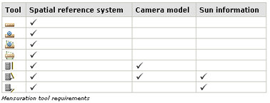
In order to be able to use the mensuration tools your imagery, ArcGIS needs the sensor model information and/or sun angle information – depending on which type of measurement you trying to do. Typically, processed or tiled imagery such as NAIP or DOQQs do not contain this information, and therefore you can’t make measurements on these images.
My image has the proper metadata but still cannot be used with the mensuration tools
Now if you have all the required information and you have ingested your imagery into a mosaic dataset and you notice you can’t measure heights, it is likely because your mensuration capabilities have been turned off on your mosaic dataset or your image service.
You can enable mensuration for a mosaic dataset by adjusting the mensuration capabilities within the Mosaic Dataset Properties window, under the General tab.
You can enable mensuration for an image service by editing the Image Service Properties.

